Sunday, September 20, 2009

Threatened with another catastrophe

RAMALLAH - The International Committee of the Red Cross has warned that Gaza's access to safe supply of drinking water could cease at any time. The World Health Organisation (WHO) says outbreaks of disease could be triggered as a consequence.

[Water desalination units in Gaza (photo: Dan Muller/Middle East Children's Alliance)]Water desalination units in Gaza (photo: Dan Muller/Middle East Children's Alliance)
The warnings follow a United Nations Environment Programme (UNEP) report Monday that "Gaza's underground water system is in danger of collapse after recent conflict compounded by years of overuse and contamination."

"An outbreak of Hepatitis A and parasitic infections could occur at any time," Mahmoed Daher from WHO in Gaza told IPS. "Already the number of people, especially children, suffering from diarrhoea has risen dramatically."

"We have noticed an increase in people suffering from kidney diseases from water contaminated with toxins, as well as babies born with an unnatural blue tinge," Munther Shoblak from Gaza's Coastal Municipalities Water Utility (CMWU) told IPS.

The UNEP report focuses on a rise in saltwater intrusion from the sea caused by over-extraction of ground water, and pollution from sewage and agricultural run-off, with toxic levels high enough to put infants at risk of nitrate poisoning.

Gaza's underground aquifer is the sole water source for its 1.5 million people. Only 5-10 percent of the water now is fit for human consumption.

The average per capita daily consumption of water for personal and domestic use in Gaza is 91 litres. WHO recommends 100-150 litres daily. Israelis consume 280 litres per day.

The UN Office for the Coordination of Humanitarian Affairs (OCHA) reported last week that at least 10,000 Gazans remain without access to the water network. Furthermore, access to water is limited on average to six to eight hours from one to four days a week for the entire population.

"Approximately 150-160 million cubic metres (mcm) are extracted from Gaza's underground aquifer annually. Due to a regional drought over the last few years only about 65 mcm has flown back into the aquifer annually. This leaves a shortfall of 100 mcm," says Shoblak.

Sewage-contaminated seawater and agricultural overflow contaminated with toxins have been flowing into the aquifer's deficit. The CMWU is only able to partially treat some of the 80 million litres of sewage pumped out to sea on a daily basis due to a shortage of spare parts, fuel, and electricity cuts.

During Israel's bombardment of Gaza during the December-January war, the strip's already degraded infrastructure was heavily targeted. CMWU estimates that about six million dollars worth damage was caused to major water and sanitation infrastructure during Operation Cast Lead, Israel's codename for its war.

Over 30 kilometres of water networks were damaged or destroyed by the Israeli military in addition to 11 wells operated by the water authorities in Gaza. More than 6,000 roof tanks and 840 household connections were damaged.

There is an urgent need for cement, pipes, pumps, transformers and electrical spare parts to implement numerous projects in the water and wastewater sector.

Some 1,250 tonnes of cement are currently needed for the repair of water storage tanks alone. But Israel's blockade prevents cement from being brought into Gaza.

Javier Cordoba, the ICRC water and habitation coordinator who is supervising Red Cross reconstruction efforts in Gaza says the situation is very fragile. "A lack of construction material and parts has led to a de-development of the water infrastructure, which could collapse at any minute," Cordoba told IPS.

"The whole system is inter-connected," Cordoba says. "Water wells use mechanical pumps to supply Gazan homes with water. The shortage of mechanical pumps and other spare parts has reduced the number of wells able to operate."

Electricity shortages force the wells to rely on back-up generators. Israel's blockade not only limits electricity supplies but the supply of industrial fuel too.

The ICRC has been working on ingenious methods to get around the blockade to bring temporary relief to Gazans.

"We have managed to build a new, albeit primitive, wastewater plant in Rafah in the south of Gaza. We used pieces of the wall which used to divide Gaza from the Sinai peninsula, before the wall was blown up last year, for the basic structure.

"We also succeeded in finding limited spare parts from Gaza to operate the plant," said Cordoba. "But this is just an interim solution, and the well will only last about five years. The more permanent and sophisticated wastewater management plant in northern Gaza still requires imported parts from Israel."

Cordoba added: "In order to relieve the pressure on the aquifer we have been digging a number of shallow wells. These again are only temporary and don't supply much water like the deeper ones, but they allow the municipalities to function again."

UNEP estimates that more than 1.5 billion dollars may be needed over 20 years to restore the aquifer back to health, including the establishment of desalination plants to take pressure off the underground water supplies.

"The international community also has to fulfil its obligations in regard to economic pledges and promises it made to establish desalination and wastewater projects," Shoblak told IPS. "Political pressure needs to be applied to Israel to allow for reconstruction and repairs."

The UNEP report warns: "Unless the degradation trend is reversed now, damage could take centuries to reverse."

Labels: , ,

Saturday, August 11, 2007

The Segregated Road to Ruin

IMAGINE a road divided down its length by a barrier imposing racial segregation. South Africa and the Southern USA only managed segregated transport, but Israel (which we mustn't dub 'Apartheid'!) has gone a step further.

Sounds crazy. But there's a method in their madness. Though madness it still is. Anyway, here's a report in the New York Times from Steven Erlanger (extracts):

August 11, 2007
A Segregated Road in an Already Divided Land
By STEVEN ERLANGER
JERUSALEM, Aug. 10 — Israel is constructing a road through the West Bank, east of Jerusalem, that will allow both Israelis and Palestinians to travel along it — separately.
There are two pairs of lanes, one for each tribe, separated by a tall wall of concrete patterned to look like Jerusalem stones, an effort at beautification indicating that the road is meant to be permanent. The Israeli side has various exits; the Palestinian side has few.
The point of the road, according to those who planned it under former Prime Minister Ariel Sharon, is to permit Israel to build more settlements around East Jerusalem, cutting the city off from the West Bank, but allowing Palestinians to travel unimpeded north and south through Israeli-held land.
“The Americans demanded from Sharon contiguity for a Palestinian state,” said Shaul Arieli, a reserve colonel in the army who participated in the 2000 Camp David negotiations and specializes in maps. “This road was Sharon’s answer, to build a road for Palestinians between Ramallah and Bethlehem but not to Jerusalem. This was how to connect the West Bank while keeping Jerusalem united and not giving Palestinians any blanket permission to enter East Jerusalem.”
Mr. Sharon talked of “transportational contiguity” for Palestinians in a future Palestinian state, meaning that although Israeli settlements would jut into the area, Palestinian cars on the road would pass unimpeded through Israeli-controlled territory and even cross through areas enclosed by the Israeli separation barrier.
The vast majority of Palestinians, unlike Israeli settlers, will not be able to exit in areas surrounded by the barrier or travel into Jerusalem, even into the eastern part of the city, which Israel took over in 1967.
The road does that by having Palestinian traffic continue through underpasses and over bridges, while Israeli traffic will have interchanges allowing turns onto access roads. Palestinians with Israeli identity cards or special permits for Jerusalem will be able to use the Israeli side of the road.
The government of Prime Minister Ehud Olmert has recently made conciliatory gestures to the Palestinians and says it wants to do what it can to ease the creation of a Palestinian state. But Mr. Olmert, like Mr. Sharon, has said that Israel intends to keep the land to the east of Jerusalem.
To Daniel Seidemann, a lawyer who advises an Israeli advocacy group called Ir Amim, which works for Israeli-Palestinian cooperation in Jerusalem, the road suggests an ominous map of the future. It is one in which Israel keeps nearly all of East Jerusalem and a ring of Israeli settlements surrounding it, providing a cordon of Israelis between largely Arab East Jerusalem and the rest of the West Bank, which will become part of a future Palestinian state.
In a final settlement, Israel is expected to offer the Palestinians land swaps elsewhere to compensate.
The road will allow Israeli settlers living in the north, near Ramallah, to move quickly into Jerusalem, protected from the Palestinians who surround them. It also helps ensure that the large settlement of Maale Adumim — a suburb of 32,000 people east of Jerusalem, where most of its residents work — will remain under Israeli control, along with the currently empty area of 4.6 square miles known as E1, between Maale Adumim and Jerusalem, which Israel also intends to keep.

For the Palestinians, the road will connect the northern and southern parts of the West Bank. In a future that may have fewer checkpoints, they could travel directly from Ramallah north of Jerusalem to Bethlehem south of it — but without being allowed to enter either Jerusalem or the Maale Adumim settlement bloc.
“To me, this road is a move to create borders, to change final status,” Mr. Seidemann said, referring to unresolved issues regarding borders, refugees and the fate of Jerusalem. “It’s to allow Maale Adumim and E1 into Jerusalem but be able to say, ‘See, we’re treating the Palestinians well — there’s geographical contiguity.’ ”

Khalil Tufakji, a prominent Palestinian geographer, says the road “is part of Sharon’s plan: two states in one state, so the Israelis and the Palestinians each have their own roads.” The Palestinians, Mr. Tufakji said, “will have no connection with the Israelis, but travel through tunnels and over bridges, while the Israelis will travel through Palestinian land without seeing an Arab.”
In the end, he said, “there is no Palestinian state, even though the Israelis speak of one.” Instead, he said, “there will be a settler state and a Palestinian built-up area, divided into three sectors, cut by fingers of Israeli settlement and connected only by narrow roads.”
Mr. Tufakji said he had become cynical about the way Israel builds for the future it defines, no matter what it promises Washington. He sees a West Bank divided into three parts by Israeli settlement blocs, the most important of which are Maale Adumim and E1, around the capital that both peoples claim as their own. “Israel is building the infrastructure to keep E1, to surround Jerusalem,” he said. “They are working to have an area of minimum Palestinians and maximum Israelis
.”
Read full article, with illustration:
http://www.nytimes.com/2007/08/11/world/middleeast/11road.html?_r=1&th&emc=th&oref=slogin


While the talk about "peace" and "two states" goes back and forth, we are told that a reasonable offer may be possible if only Palestinians are prepared to "recognise Israel" (but they are required to recognise it was right all along, thus abandoning their own struggle's claim to legitimacy, rather than merely accept it as a fact). But meanwhile Israel goes ahead creating facts on the ground, taking measures designed to establish for all time its own supremacy.

It's ironic that British and American governments still talk about a "road map for peace". The real road map that is emerging, with separate roads and now a road that is segregated, is headed somewhere else. There is method in the Israeli authorities' madness. Very clever use of topography and now topology too, -what a wonderful exercise for students to make their project. But with the perpective that one nation can just displace or rule over another, for ever, while its defenders still inist it only wants peace, madness it certainly is.

Labels: , ,

Wednesday, August 08, 2007

Waiting on the Levee? Demonstrating on the Levee!

AFTER that last piece on the United States, and with floods having recently hit several parts of Britain, it seems only right and topical to remember folks in New Orleans, with this story, from a posting by Helen Ingram to Labour Left Briefing List:

A reinforced levee and floodwall protects Jefferson Parish, a demographically whiter and wealthier neighbor of OrleansParish, from the Monticello Canal. The Orleans Parish side of the canal has virtually no flood protection. The current city drainage system pumps more water into the canal than is pumped out, often flooding the predominantly working class African American Orleans Parish neighborhood of Carrollton-Hollygrove.

"This neighborhood has always flooded during heavy rains," longtime resident and ACORN neighborhood chair Joe Sherman told protesters. "Our community is left vulnerable while the state, the Corps of Engineers and the Water and Sewerage Board keep pointing fingers."

Stephen Bradberry, Louisiana ACORN headorganizer and 2005 Robert F. Kennedy Human Rights Award winner noted, "The risks increase for these residents because there is protection on one side, and no protection on the other."

Dr. Robert Bea, lead investigator on the National Science Foundation's inquiry into New Orleans' flood protection system, confirmed that placing a levee and floodwall on one side along theMonticello Canal but not the other had no grounding in science."It is perfect example of the disconnected incomplete nature of this flood protection system," said Dr. Bea. "Much of what happened [there] during Katrina represents the left-overs from the age of slavery in the south."

And from the Times-Picayune:

Protesters join hands to form 'human levee'
Sunday, July 29, 2007
By Ginger Gibson Staff writer

Residents of the Carrollton-Hollygrove area know that when heavy rain hits, the risk of water from the Monticello Canal overflowing into the streets, and possibly their homes, increases drastically. But the threatening rain clouds Saturday morning didn't stop about 120 people from assembling along the canal, joining hands and forming a three-block-long "human levee" to symbolize the need for better protection on the Orleans Parish side of the drainage way.

Neighborhood residents, members of the Association of Community Organizations for Reform Now and visiting volunteers took part in the rally Saturday to raise awareness of what they say is inadequate protection and a lack of concern from city, state and federal officials. They were joined by Kerry Kennedy, a human rights advocate and the daughter of Sen. Robert F. Kennedy.
The canal, which separates Orleans and Jefferson parishes and is higher on the Jefferson side, is used to pump rainwater out of the city during storms. The Monticello and Palmetto canals merge to form the 17th Street Canal.
Robert Bea, an engineering professor at the University of California-Berkeley, who conducted a post-Katrina study of flooding in New Orleans, said the problem with the Monticello Canal is twofold and the result of years of unorganized, loosely supervised engineering.

As water from the two canals moves into the 17th Street Canal, the water from the Palmetto prevents a continuous flow from the Monticello. The water backs up into the Monticello and without an adequate levee overflows into the Orleans Parish side.

"(The rally) is an excellent example of people uniting to say 'We're concerned, and we're not stupid. We can see we've got a problem here,' " Bea said from California.

'Sense of community'
Some relief is coming, New Orleans Councilwoman Shelley Midura said. After touring with representatives from the state Department of Transportation and Development and the city's Sewerage & Water Board on Friday, she said a study will begin soon to determine the exact cause of the flooding.
The DOTD also is going to provide concrete barricades to line the canal, preventing cars from entering it -- a concern residents had expressed before, Midura said.

Kennedy told those assembled that the lack of priority for the construction of a levee along the Monticello Canal went against international law and was a testament to the city of New Orleans' lack of concern for minorities.
"We will not be washed away," Kennedy said. "We will not be washed away in New Orleans east. We will not be washed away in Gentilly. We will not be washed away in New Orleans' 9th Ward."

'A great turnout'
While the young volunteers from two Unitarian Universalist churches included the rally as part of their weeklong trip, Mary Shaw, a Hollygrove resident, has been participating in efforts to raise awareness about the problem for several years.
She was accompanied by her neighbor Lorelei Holmes.
"This is a great turnout," Holmes said.
Shaw said that in the 38 years she has lived in the area, her home has flooded eight times -- including during Hurricane Katrina, when there was 8 feet of water in the house. She has rebuilt and moved back in.
"I come to give support," Shaw said. "They've been talking about doing this for years."
(full article at http://www.nola.com/metro/t-p/index.ssf?/base/news-23/118568881176670.xml&co)

See also:
http://www.rfkmemorial.org/legacyinaction/2005_HumanLevee/

Labels: ,

Tuesday, August 07, 2007

Bridge collapse reveals system faults

AMERICA'S love of the automobile is a well-worn cliche, but seems the lover can be a cheapskate when it comes to spending on infrastructure. Or maybe it's how politicians misjudge what's necessary to maintain popularity.

At least five people are known to have died in the collapse of the Interstate 35W bridge in Minnesota. What caused the collapse is still being investigated. But writing from Minneapolis, Susan Saulny and Jennifer Steinhauer point out in the New York Times that "In the past two years, Gov. Tim Pawlenty of Minnesota twice vetoed legislation to raise the state’s gas tax to pay for transportation needs".

Pawlenty, a Republican, may be having a rethink. “He believes we need to do everything we can to address this situation and the extraordinary costs,” says an aide.

"Even as the cause of the bridge disaster here remains under investigation, the collapse is changing a lot of minds about spending priorities, " say the two US reporters. "It has focused national attention on the crumbling condition of America’s roadways and bridges — and on the financial and political neglect they have received in Washington and many state capitals.

"Despite historic highs in transportation spending, the political muscle of lawmakers, rather than dire need, has typically driven where much of the money goes. That has often meant construction of new, politically popular roads and transit projects rather than the mundane work of maintaining the worn-out ones.

"Further, transportation and engineering experts said, lawmakers have financed a boom in rail construction that, while politically popular, has resulted in expensive transit systems that are not used by a vast majority of American commuters.

"Representative James L. Oberstar, Democrat of Minnesota and the chairman of the Committee on Transportation and Infrastructure, sent out a news release last month boasting about Minnesota’s share of a recent transportation and housing appropriations bill.

"Of the $12 million secured for the state, $10 million is slated for a new 40-mile commuter rail line to Minneapolis, called the Northstar. The remaining $2 million is divided among a new bike and walking path and a few other projects, including highway work and interchange reconstruction.
The $286 billion federal transportation legislation passed by Congress in 2005 included more than 6,000 earmarks, which amounted to blatant gifts to chosen districts, including the so-called Bridge to Nowhere in rural Alaska (that earmark was later removed after a political uproar)".

Federal money tends to be earmarked for construction, not maintenance State politicians may decide where a road should go. “The bottom line,” says Senator Charles E. Schumer, “is that routine but important things like maintenance always get shortchanged because it’s nice for somebody to cut a ribbon for a new structure.”

A study released in May by the Urban Land Institute and Ernst & Young found that 83 percent of the nation’s transportation infrastructure was not capable of meeting the country’s needs over the next 10 years. The American Society of Civil Engineers, in its latest national report card, gave transportation infrastructure a D.

"Meanwhile, there are urgent needs. The Interstate highway system turned 50 last year and is showing signs of age and inadequate upkeep. Around St. Louis, for instance, old bridges, rocky roads and tight ramp loops have led to a shutdown of parts of Interstate 64/Highway 40 — one of the most important corridors in the state — until late 2009".

America's national highway system, originally called the National System of Interstate and Defense Highways, came into being under the Eisenhower administration. It was spurred by fears of a mobility crisis if the country were attacked in a nuclear war. By the 1970s much of the system was completed.
But since then, the nation’s highways have eroded with age and use.
http://www.nytimes.com/2007/08/07/us/07highway.html?_r=1&th&emc=th&oref=slogin

Labels: , ,

Wednesday, August 01, 2007

Wiped off the face of the Globe


WHEN Iranian president Ahmadinejad was reported as saying that Israel would be "wiped off the map" there was a worldwide row, linking what he told a lunchtime crowd with Iran's supposed plans to acquire nuclear weapons. It is said a lie can zoom around the world before the truth can get its boots on, and it seems it can keep on going after truth has sat down to rest and take them off again.

It may have suited Ahmadinejad to play the bogeyman supposedly terrorising Israel and the West, though in reality the president has less say in Iranian policy than is imagined. If the nuclear threat were real it would terrify the Palestinian people, who want to live free in their homeland, not perish with the occupier amid radio-active ruins. As it is the people really endangered are the Iranians, as their president's posturing sets them up for US imperialism's next war of intervention.

But in any case, it seems that what Ahmadinejad really said was that "the regime now occupying Jerusalem will be wiped from the history books". In case there's any doubt about interpretation, he had compared it with the way the Soviet Union eventually collapsed after its unsuccessful war in Afghanistan. Western politicians may claim the USSR's collapse as a victory, but it was not achieved by nuclear war, and I've not heard anyone claim it meant the same as destroying the Russian people.

(for an earlier comment on Ahamdinejad speech, see http://randompottins.blogspot.com/2005/10/war-kills-people-not-maps.html

Still, even if Ahmadinejad had said something about wiping Israel "off the map", there's some irony in the way people affect outrage over that, when for so long the nation which has been wiped from maps has been the Palestinians.

Every so often there's a fuss made over some Arab map or whatever not acknowledging the existence of the State of Israel, but as Eyal Weitzman has pointed out, Israeli cartography has had more than a symbolic significance when eliminating troublesome features: "Whatever the nature of Palestinian spatiality, it was subordinated to Israeli cartography. Whatever was un-named ceased to exist. Scores of scattered buildings and small villages disappeared from the map, and were never connected to basic services".


There was a time when people went on about Israel's need for "secure borders", but when I paid my second visit in 1986, the pre-1967 armistice line which separated the state of Israel from occupied territories had disappeared from the maps we were given by the Israeli Ministry of Tourism. Indeed as Cecilie Surasky tells us, there was a row in Israel when a government minister suggested this "green line" should be shown on maps.

"Last December, Gershom Gorenberg, the author of the highly recommended The Accidental Empire: Israel and the Birth of the Settlements, wrote that in 1980……maps showing the Green Line were impossible to find in Israel. (The diplomat said his maps came from the CIA.) The Israeli government’s cartography service had a monopoly on the map market. You could get topo maps showing the location of every picnic table and archeological site in the country, but not the boundary between Israel and occupied territory. Maps showed only the post-1967 lines dividing Israeli-controlled land from neighboring Arab countries. In official cartography, occupied Hebron and Nablus looked like part of Israel. The practice tended to obscure political developments. As a journalist, I often covered settlement in the West Bank — but when a new community was established, sometimes I wasn’t sure whether it was in Israel proper or in land conquered in the June 1967 Six-Day war.
Government maps still dominate the market, and still don’t show the Green Line. Neither do schoolbooks. But this week, Education Minister Yuli Tamir issued instructions to show the border line in new textbooks. Tamir, a founder of the Peace Now movement, represents the center-left Labor Party in Prime Minister Ehud Olmert’s crazy-quilt coalition. Right-wing pols immediately accused her of politicizing the classroom. Benjamin Netanyahu’s opposition Likud said it would call for a parliamentary vote of no confidence. A group of rightist rabbis said Tamir had “declared war against God” by suggesting a division of the homeland divinely granted to the Jews. None of the rightists, naturally, find any trace of politicized education in the practice of hiding from children the borders of their own country. In a curious way, though, they have a case: In Israel — and not just in Israel — facts are political. Denial is the consensus position.

Gorenberg went on:
'For nearly 40 years, Israel has treated its own border the way Victorians treated sex: It shapes society, but explicitly portraying it violates respectable conventions. Those who do so are seen as daring, not quite part of polite society. Bright children know the border exists from adult conversations, know it will be terribly important when they come of age, and are not quite sure what it looks like. My daughter, child of an impolite father, asked her high school geography teacher why the Green Line was missing from a map he handed out, and left him wordless'.

We keep hearing from Israel's "Friends" and from Western politicians about the "Two State solution", but do Israeli leaders believe a word of it or is the concept solely for export? (I won't go into those left anti-Zionists who hail the supposed "impossibility of the two-state solution" now as though it meant we were any closer the prospect of a bi-national or democratic Palestinian state in the whole of Palestine. That's wishful thinking, but another discussion). While they demand that Hamas recognise Israel's right to exist, that is, legitimacy as a state, they refuse to recognise that Palestinians as a nation do exist, other than as a "problem". Since there is no such place as Palestine, how can it be "occupied"? "Occupation - What occupation?"

This arrogant refusalism extends to Israel's friends in the West. A Palestinian film-maker was told his work could not be billed as made in "Palestine" because there was no such country.

A German toy maker ran into this barrier when it produced a globe that was meant to be an educational toy.
The Jerusalem Post reported in November 2006
'Pro-Israel advocacy groups campaign around the globe against the use of the word Palestine, since no such country exists, but it turns out that globes being sold in Israel bear the term.
Billed as an educational toy that teaches young children geography, the widely sold “Ravensburger Puzzle Ball Classic Globe” includes both Israel and Palestine. Although the product has been on the market for more than two years, all of those contacted by The Jerusalem Post, from toy store owners to the Israeli distributor to the German manufacturer, reacted with surprise when informed of the imaginative geography.
“The first time I learned about this issue was when [the Post] told me,”said Hermann Bruns, an export manager for the manufacturer in Ravensburg, Germany. He said the design for the map was bought from a Chinese company, and that Ravensburger was only responsible for repackaging it.
Demands to change the design have been quick to follow discovery of the error, with those involved in distribution and sales of the globe in Israel saying they have appealed directly to Ravensburger.
“I was very, very angry when I found out about this,” said Meir Klughaft, CEO of Saheknu, which imports the puzzle globe. “I personally asked [Ravensburger] to change the product, and to remove the word Palestine and leave only Israel. They promised me in a letter that they would.”

Israeli politicians have objected to the word "Nakba" (catastrophe) to describe the 1947-8 exodus of Palestinians, in Arab school textbooks. It seems they have been more successful in expunging reality from German educational toys. Israeli peace campaigner and feminist Dorothy Naor reports:
'This evening’s Yoman (i.e., journal; a regular Friday feature on Israeli TV channel 1) had a segment on puzzles. In concluding it, the reporter proudly announced a change that the Ravensburger company had introduced. Apparently one of its products is a jigsaw puzzle of a globe of the world. In the past it had on it Palestine. But after an Israeli complained, Ravensburger dropped Palestine, and replaced it with Israel and Jerusalem.
While it is true that the Palestinians were dispossessed of a country in 1948-9, that does not mean that they do not exist, nor that they should not be recognized! At the very least, the West Bank, East Jerusalem, and Gaza should be on the globe as Occupied Palestinian Territory.
Please write protest letters, or letters requesting righting the wrong to Ravensburger
E-mail info@ravensburger.de

Protests have received this pro forma letter from Ravensburger:
"The old version of the puzzle was an already existing, manufactured product from China that we took over in our programme.
We acquired the new cartographic material from the European market leader for maps and globes, on whose expertise and correctness we rely. Our endeavour is to develop games and books that give pleasure to children and families, but interpreting maps does not fall within our sphere of specialisation".

Thanks for this story to Cecilie Surasky of Muzzlewatch, a service run by Jewish Voice for Peace in the US, exposing intimidation and censorship.

Labels: , , , ,

Tuesday, July 24, 2007

Nuclear waste in flood path?

NUCLEAR waste from a shut down nuclear power plant could be in the swirling flood waters in Gloucestershire. A BBC television reporter this evening hinted that, as well as halting power supplies from Castle Meads power station and Walham switching station to homes and the GCHQ base at Cheltenham, the floods could have affected a nuclear site, which he could not name.

Castle Meads has been restored and Walham could be working again, after a huge effort by Royal Navy teams and emergency services. The county had been facing a complete blackout, and there were plans for a mass evacuation, it was reported tonight. The army is distributing bottled water to 350,000 people in Gloucestershire - and it may have to last them two weeks.

Berkeley nuclear power station was the first commercial nuclear plant in Britain and is the first to be decommissioned. It also houses laboratories.
http://www.sitestakeholdergroups.org.uk/berkeley/

But though the reactors have been closed, there are still large amounts of untreated nuclear waste at the site. Questions were asked about plans to store the Intermediate Level Waste(ILW) and the need to maintain flood defences at a meeting of nuclear industry management and local councillors, in March.

A temporary waste store for the ILW was being set up.
People in Lydney (where there has been concern over the incidence of child cancers) had asked why waste could not be left in vaults until a national repository was built. But Berkeley director Mr.J.Crocker said the problem was that the vaults were below the water table.

"Dr.Hellen asked where the risk of flooding sits. Mr.Crocker replied that the vaults have flooded before and the risk remains of it happening again. Storing the waste in the proposed ILW store reduces these risks of flooding in future to a low level."
http://www.sitestakeholdergroups.org.uk/berkeley/upload/Berkeley-Site-Stakeholder-Group-Meeting-Minutes-1-March-2007.pdf

Questions were asked in parliament a few years ago about dangers at Berkeley from a different direction. Llew Smith: To ask the Secretary of State for Trade and Industry what physical protection measures exist at the Berkeley nuclear research laboratories in Gloucestershire against the accidental or deliberate crash of an aircraft onto the site; and whether these have been enhanced since 2002. [171649]
Mr. Timms: The UK's civil nuclear sites apply stringent security measures regulated by the Office for Civil Nuclear Security (OCNS), the security regulator. The security regulator works closely with the Health and Safety Executive, the safety regulator, which provides advice on the safety implications of events, including external hazards such as plane crashes, at nuclear installations. Security at nuclear sites is kept under regular review in the light of the prevailing threat and has been significantly enhanced since the terrorist attacks in the USA on 11 September 2001. It is Government policy not to disclose details of these measures which could potentially be of use to terrorists
http://www.publications.parliament.uk/pa/cm200304/cmhansrd/vo040510/text/40510w21.htm

MoD confirms nuclear near-miss
Defence bosses have confirmed that a US fighter jet came within a few hundred feet of the former Berkeley nuclear power station in Gloucestershire.
The Ministry of Defence also confirmed two breaches by RAF helicopters of the anti-terrorist no-fly zone around the decommissioned plant.
The MoD said the three incidents since the September 11 attacks had been accidental.
There had been no risk to people or property, the MoD said.
Sunday, 2 May, 2004,

http://news.bbc.co.uk/1/hi/england/gloucestershire/3678785.stm

Berkeley is not the only nuclear site in the area. Oldbury further down the Severn has had other problems, as this report tells from Friday, 13 July 2007:

Nuclear power plant closed again
A nuclear power station has only been open for a total of eight days since August, it has been revealed. Oldbury Power Station in South Gloucestershire recently closed for an undisclosed reason, three days after reopening at the end of June.
It was also closed at the end of May after a fire at the plant.
Plant manager Pete Harper said: "Our number one priority is safety. We wouldn't run this plant if it wasn't safe to do so."
He added that the plant would only be brought back on line when it was safe to do so.
Oldbury is due to stop generating electricity at the end of 2008.
http://news.bbc.co.uk/1/hi/england/bristol/6897062.stm

Maybe the people affected by the floods have enough misery without adding panic. But the true picture will have to come out if people are to know what to expect, and what steps need to be taken for future safety. "What you don't know can't harm you" was never a sensible belief, as we are learning.

Labels: , ,

Tuesday, October 24, 2006

"Buried alive by the NCB"


Forty years after disaster at Aberfan

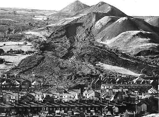
At 9.15 am on Friday, October 21, 1966 a waste tip slid down a mountainside into the mining village of Aberfan, near Merthyr Tydfil in South Wales. Down below it was foggy in the valley, and people heard the rumble before they could see what was happening. The black avalanche destroyed a farm cottage in its path, killing all the occupants. It continued down to Pantglas Junior School, where the children had just returned to their classes after singing All Things Bright and Beautiful at their assembly.

Gaynor Minett, an eight-year-old at the school, remembered four years later:
"It was a tremendous rumbling sound and all the school went dead. You could hear a pin drop. Everyone just froze in their seats. I just managed to get up and I reached the end of my desk when the sound got louder and nearer, until I could see the black out of the window. I can't remember any more but I woke up to find that a horrible nightmare had just begun in front of my eyes."

Men working above the tip had tried to run and give warning. They had no phone, apparently because the cables had previously been stolen. In any case even a 'phone warning would not have ennabled anyone to move in time, it all happened so quickly. The slide engulfed the school and about 20 houses in the village before coming to rest. Altogether 144 people died in the Aberfan disaster: 116 of them were school children. About half of the children at Pantglas Junior School, and five of their teachers, were killed.

"Buried alive by the NCB!" was one father's bitter verdict, shouted aloud at the inquest. Though volunteers had rushed to help local people and rescue teams at the disaster scene, Lord Robens of Walsingham, the former Labour MP Alf Robens, chairman of the National Coal Board (NCB) had carried on with his scheduled business, going to accept an appointment as chancellor of the University of Surrey. He would try and hide the causes of the slide and claim that nothing could have been done to prevent it. He never apologised.

A Tribunal of Inquiry found that the National Coal Board had been responsible for the disaster, "due to ignorance, ineptitude and a failure of communication".
The Aberfan disaster was not some unpredictable freak of nature. It could have been foreseen. Aberfan lies below Merthyr Mountain, on the bank of the River Taff, near the Merthyr Vale colliery. Like other mountain areas in Britain it has a high rainfall. Where mining subsidence has accentuated cracks in the sandstone of the mountain, the water penetrates down until it reaches layers of coal or clay, when it bubbles back to the surface as springs and streams down the slopes. One such stream was buried under Tip 7.

As far back as 1927 a Professor Knox delivered a paper to the South Wales Institute of Engineers in Cardiff, warning that if water accumulated in tips it would cause landslides. Collieries which failed to pay for drainage to remove the water would end up paying compensation for the results. Among those who studied this paper was a man who would later be Production Director of the NCB's South Western Division, covering Merthyr Vale, near Aberfan.

Before nationalisation, in 1947, the mines in this area were owned by the Powell Duffryn company. It was at one of their collieries, the Albion, five miles from Aberfan, that on December 5, 1939, some 180,000 tons of wste from a tip slid down the hillside, into the road, the canal and the River Taff. Powell Duffryn commissioned a consultant engineer to investigate, and he produced a study called "The Sliding of Colliery Rubbish Tips".

In November 1944 a large part of the conical Tip No.4 at Merthyr Vale slipped down the hillside. The tip had partly lay on loose material left from an earlier slide. Earlier that year company officials had assured the local council that there was no immediate danger from the tip, and said they were starting to have drainage trenches dug. When the November slip happened the colliery agent blamed the rain, and told the council it could have been worse but for the drainage channels. In fact the No4 tip had buried 400 foot of a stream.

By the time of the Aberfan disaster the waste was being tipped on Tip.No7, and there was a new danger. Mechanised mining methods brought a new kind of waste, fine dust left when the smallest amounts of coal were extracted. These tailings could not be piled high as more solid material, and their inclusion considerably lowered the "angle of repose" at which a pile would settle significantly. In rain they could turn to a wet slurry, sliding down into watercourses, then drying to form a solid blockage behind which more water accumulated until it flooded.

Already in 1959 and 1960 the council, backed by the Merthyr Vale Labour Party, had raised concern over flooding and the dangers of tip slides. In 1963 part of the foot of Tip No.7 was washed away by a spring, leaving a steep face over 70ft. high. A consulative committee, attended by miners' representatives and others on November 26, 1963, heard fears of further slides. The colliery manager visited the tip, and decided tipping of tailings must stop. There had already been a decision in the South Western Division that such waste should be poured into disused shafts. But the tipping continued.

On March 29, 1965, at Tymawr, a tailings lagoon held behind rubbish at the base of a tip burst its banks and flowed over railway tracks and the main road for hundreds of yards, wrecking cars in the car park and threatening to flow into the mine shafts. It cost the NCB £20,000 but somehow the incident never made into records at the Board's headquarters. Nor had the 1963 slides of waste at Tip 7 over by Aberfan.

Yet local people did express fears about what could happen if waste contnued to be tipped on the hillside behind their school. The Merthyr Express reported on January 11 1964 that a local councillor warned a planning meeting "if the tip moved it could threaten the whole school".

Perhaps other voices were getting more attention. On 7 July 1965, the colliery manager and senior engineers from the area NCB visited the Aberfan tips with the managing director of a fuel company that was interested in reclaiming coal from the waste tips. Apparently they saw no evidence of anything wrong or any instability.

And so on Friday, 21 October 1966, at 9.15 am, after smaller movements, the big slide began. Down the hillside came 140,000 tons of waste. At the bottom part it appeared as liquid, like a cold black lava tide. Smashing through two mains water pipes its flow increased, crossing a railway embankment to engulf more homes.

The tribunal found that the disaster could and should have been prevented. The main cause was a build-up of water in the pile and, when a small slip occurred, the disturbance caused the saturated, fine material of the tip to liquefy and it flowed down the mountain. In 1958, the tip had been sited on a known stream (as shown on earlier Ordnance Survey maps, and it had previously suffered several minor slips. Its instability was known, both to colliery management and to tip workers but very little was done about it. The Merthyr Tydfil Borough Council and National Union of Mineworkers were cleared of any wrongdoing. No NCB employee was sacked, demoted, or even disciplined. The NCB was ordered to pay compensation, though much of this was made up by government, and compensation to local families was later reduced because they had received sums from an appeal fund.

Labour's nationalisation of industries like coal in 1947 did not remove them from capitalism. On the contrary, they were expected to show a profit after paying out interest on loans made to compensate the former coal owners, who had risked miners' safety and pocketed subsidies, and continued recieving payments even when their former mines were closed as "uneconomic". State owned industries were modernised at public expense to serve the private sector, while neither their workers nor the public gained any control over bureaucratic management.

Bosses and bureaucrats anywhere, management members, aim to increase profit, keep down costs, empty their in-trays, look the other way when necessary, endear themselves to their superiors, raise their status and earnings, and make sure anything that goes wrong will be blamed on someone else, preferably lower down in the workforce, or on unpredictable factors beyond their control. Anyone, manager or worker, who sees their responsibility to the wider comunity, the environment and humanity is asking for trouble with their careers, and woe betide the worker who speaks out of turn let alone expects a say in things.

Since Aberfan we have seen several major disasters, not least in the Thatcher era of "deregulation" - the Kings Cross fire(1987), the sinking of the aptly- named Herald of Free Enterprise off Zeebrugge(1987) and the Marchioness pleasure boat in the Thames, and major rail crashes, not to mention the continuing toll on workers' lives in the construction industry. Nor can we forget that this year was the twentieth anniversary of the Chernobyl disaster. State ownership with bureaucratic rule and control of information does not equal socialism. But we know that if global capital continues its way, under whatever political labels, the planet itself is threatened.

At the Labour Party conference in Manchester last month the party leadership was defeated on issues of public housing, privatisation in the Health Service, and the watering-down of the government's long awaited Corporate Manslaughter and Homicide Bill. Transport and General Workers' general secretary Tony Woodley said the bill only allowed companies to be fined, and would give guilty directors a "get out of jail free" card.

We will see whether this government takes more notice of union or Labour party members, or continues listening to the City and big employers. The tide of opinion in this country has swung against big business and privatisation, but on this as on the peace and war issues, the public mood still needs to find political expression. Socialists should be getting far more support, but whether in the Labour Party or out of, we have to ask how we realise this potential.

As we remember the victims of Aberfan, the children slaughtered when their lives had hardly begun, let us recognise the human cost of continuing to subordinate everything to profit, and the need to gain not just public ownership but democratic control by society over our industries and environment. It is a life and death question.

ACKNOWLEDGEMENTS

Much of the information about the history leading up to the disaster is from Victor Bignell's study on the Aberfan Disaster in Catastrophic Failures, published 1977 by the Open University.

I was spurred to write something on this by a TV news item on the village marking the anniversary, but also by fellow-blogger Mark Elf covering it in his blog Jews Without Frontiers. He also provides a reference to other resources at
http://www.nuff.ox.ac.uk/politics/aberfan/home2.htm

Labels: , , ,

Friday, December 09, 2005

Geography, and Knowing your Place

MAN OF THE MOMENT (1955).
Norman Wisdom solves world crisis.


SOME years ago I was browsing in a Job Centre within sight of Big Ben when I spotted a job card on which the only qualifications required seemed to be British nationality and parentage. On enquiring I was told to write to the government department concerned. Being not so much optimistic as desperate at the time, I did. As a result, much to my surprise, a few months and an application form later, I stepped into an elegant stuccoed terrace house near St.James' Park and sat down to an aptitude test.
I had better go careful on detail as the government is swinging out with the Official Secrets Act, But anyway, you'll be relieved to know that my codebreaking skills, fieldcraft and small arms expertise were not examined. I just had to play an amusing computer game juggling supposed room users among a set of meeting rooms on a diagram, do some sums, and proof-read columns of figures.
Friends, and even more my late beloved parents oleh b'shalom, would be surpised to hear I passed.

But then came a short preliminary interview, just to see if I was worth sending before the proper interview panel. "You mention that you are interested in better understanding between nations. What do you mean by that?" The interviewer's expression of distaste did not look too encouraging As to my mention of visits to Israel and Bosnia to illustrate my interest in world affairs, this seemed to strike her as highly suspect. And that wasn't all.

"Under 'administrative experience' you say that you took part in a committee arranging a trade union conference. ... Do you think trade unions have any place in the modern world?"
She affects incredulity. I say, affecting a sage statesmanlike air, that yes, people do need representation in the workplace and it can make for better relations. I sense she is not impressed.

It gets trickier. The Department is part of the civil service, the interviewer explains, and has to work with the governemnt of the day, regardless of its political complexion. Sounds fair enough.
"We can't let our own political views influence us...Do you have any strong political convictions yourself?"

"Well", I drawl, trying to sound old and wise again, "when I was young I thought things were simple, but as I get older I realise the world is more complex, and there's more than one side to the story...." The interviewer seems about to yawn as I waffle on. OK, better give her something. "I suppose you could say I'm still a socialist of sorts...."

"You realise the panel will take a dim view of that!"
Oh well, and there I was nearly forgetting that in Britain "no politics" means being safely conservative.

On to easier questions. How well would I get on working with younger people, would I wear a tie, what did I think I could contribute to the job? I venture to say that I am industrious, resilient, have a sense of humour, and ....
"My knowledge of geography might come in handy"

"You'll get no chance to use that here!"

I'm not sure if her indignant tone is genuine or meant to test my afore-mentioned sense of humour. I can't resist a slight grin as I remember the moment in "Carlton Brown of the FO" when they are desperately searching through dusty old maps to find out where on earth a suddenly-important island is.

A day or so later I heard that I had not got the job. Pity. I wasn't seriously expecting to save the world or set Britain's policies right, but it had seemed a nice place to work, and sorting out who went into which room might have been fun, even if my status might have been like Norman Wisdom in that other film, coming to work among the mandarins, with his sandwiches and flask in a carrier-bag marked in biro "E II R" Still, I wouldn't have to struggle into a tie.

Talking to a mate in the pub, he laughs when I get to the geography bit. "Of course, you know that Giles works in that Department don't you?"

"No!"

Giles is a young chap who comes in the same pub, nice chap, always looks neat and smart, white collars and dark tie, trim moustache, an expert on military bands I'm told, but I'd taken his place in the pub quiz team when he was dumped for too many duff answers.

It occurs to us then that there is method in the ministry's madness. So long as you have a fellow who can put the files in order or take a message, you don't want them taking too much interest in the places the files are about, or which airport someone is 'phoning from. Or you might indeed have someone with opinions, even a "security risk". Worse, on hearing Sir Montague Ffortescue-Smythe saying he doesn't know where some godforsaken island is, or confusing his Slovenia and Slovakia, say, a lowly menial might forget their place, and seek to advise or correct their better - and such lese majesty, as we know, could seriously undermine society. (I know, I've sometimes made the mistake of trying to be helpful in other jobs, it's a good way of getting to the top - of the redundancy list).

So there you have it kids, make sure you do well in history and geography at school, and you'll probably not get a job, but you can be the toast of your pub quiz team and the smartest guy in the Labour Exchange (or Job Centres as they're now amusingly described).


What brought on this story? Well apart from it being one I wanted to tell, I've just been reading how residents of Balmore Street in Dundee, Scotland, were bemused to recieve a glossy consultation pack describing a proposed controlled parking zone and 20mph speed limit with "traffic calming" (speed humps) and inviting their comments. Most thought it was a bit daft asking, since the proposals were from Camden council in north London, and related to Balmore Street in Highgate - only 500 miles south from them. (Bungled humps mailshot to Dundee really takes the cake Camden New Journal, December 8).

Reminds me of when I was working for Associated Electrical Industries(AEI) and someone reputedly put the wrong labels on a packing case so that a huge piece of switchgear equipment was shipped out to Singapore when it should only have gone to Walthamstow power station. Mind you, I could not verify that story whereas the Camden mailshot seems genuine. AEI was eventually taken over and shut, but Camden's mistake will be paid for by council taxpayers.

What I find hard to imagine when I read stories like this is someone labelling all this mail and someone franking it for the post and nobody apparently noticing anything wrong or stopping to ask about it. "Computer error" -clot at the keyboards I suppose. Mind you have you heard some of the daft answers you get people giving on quiz games these days? And they've nearly all got good jobs, at least when they say what they do at the start I haven't even got a clue what it means half the time.
I'm getting old.


Labels: ,